Hiking in the Azores: The Best Trails on Sao Miguel

BY JARED DILLINGHAM
AZORES HIKING TRAILS: THE BEST ON SAO MIGUEL ISLAND
Hiking in the Azores is part of a dream trip to this unique, remote island chain, far off the coast of Portugal. I’m going to focus on hiking trails on Sao Miguel, which is the most popular island for visitors.
The Azores hiking trails lead to waterfalls, volcanic lakes, amazing viewpoints, and along stunning coastlines. They vary in degrees of difficulty, but for the most part, you’ll find Sao Miguel’s best hiking trails to be accessible and manageable for most hikers.
Renting a car is the best way to visit the Azores hiking trails!
Rental car rates are very reasonable in Ponta Delgada (at PDL Airport), and the roads around the island are easy to navigate.
I usually use Discover Cars when I book, because they include the local Azorean rental agencies (which are quite good) in addition to the better-known international car rental brands.
🚘 Click to Search Rental Cars in the Azores
🌎 Blog: Renting a Car in the Azores
If you’d rather stay in Ponta Delgada, and have someone else guide and drive you, I’d recommend these tour options for different Sao Miguel hikes:
➡️ Click to Book: Sao Miguel Hike
- 12km hike around one of the volcanic lakes.
➡️ Click to Book: Sete Cidades Hike
- ATV tour plus hike around Sete Cidades.
➡️ Click to Book: Azores Waterfall Hike
- Hike with a guide to Salto do Prego.
Now, let’s Get to the best Azores Hiking Trails!
The Best Azores Hiking Area: Sete Cidades
Sete Cidades is an area on the western side of Sao Miguel Island, known for its stunning volcanic lakes and breathtaking landscapes. The area offers several hiking trails, which allow visitors to explore the natural beauty of the region.
Here are some of the popular hiking trails in Sete Cidades:
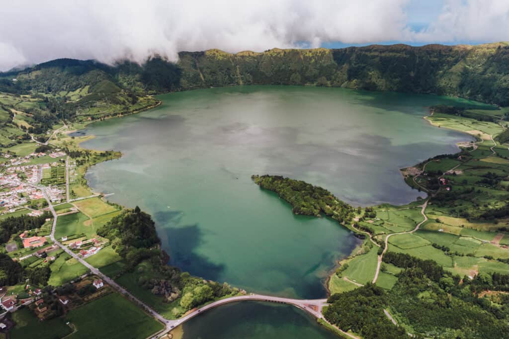
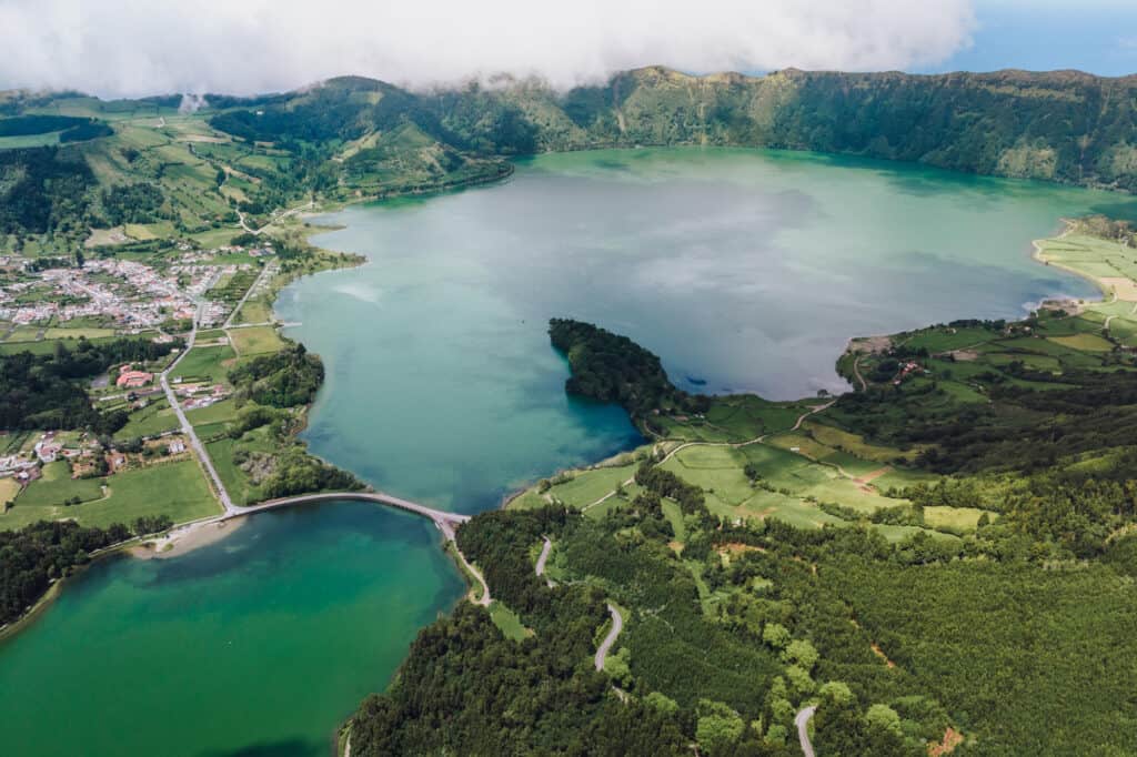
- Sete Cidades Caldera Rim Trail: This is one of the most famous hiking trails in the Azores. The trail takes you along the rim of the massive volcanic caldera that holds the twin lakes, Lagoa Azul (Blue Lake) and Lagoa Verde (Green Lake). The sun, the mineral content and the depth of the water will make one lake appear more blue, and one more green. The hike offers stunning panoramic views of both lakes, the lush vegetation inside the caldera, and the Atlantic Ocean in the distance. The entire loop around the caldera rim is approximately 7.5 miles.
- Cumeeiras Trail: This trail starts near the village of Sete Cidades and takes you through meadows and woodlands. The path leads to various viewpoints with fantastic vistas of the Sete Cidades Lakes and the surrounding volcanic landscape. The Cumeeiras Trail is just under 4 miles long.
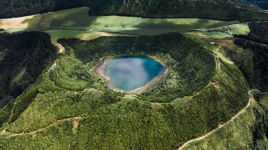
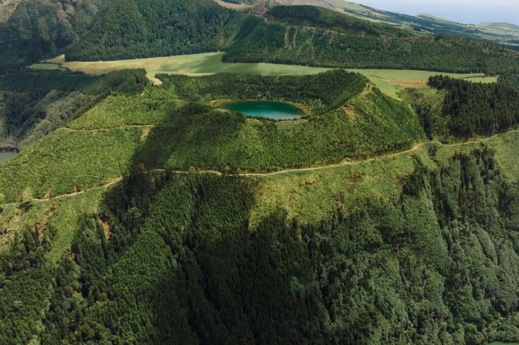
- Santiago Lake Trail: This trail leads to Lagoa de Santiago, another lake near Sete Cidades. The hike takes you through forests and is shorter, just over one mile in length.
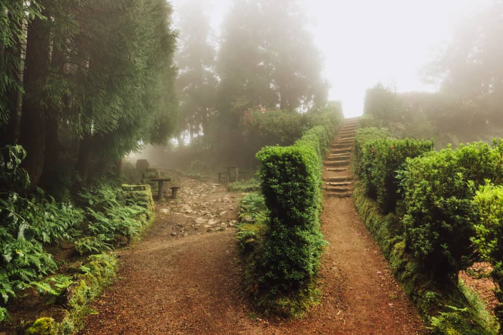
Visto do Rei (Sete Cidades)
Vista do Rei is one of the most famous and iconic viewpoints on Sao Miguel, and is one of the more famous Azores hikes. It’s also in the Sete Cidades area, but since it offers a few unique options, I’m breaking it out into its own section.
You’ll have several hiking options here. You can park in the lot, or right along the road, and hike one of several trails which begin there.
You’ll get the same panoramic views of the Lagoa das Sete Cidades (Lake of the Seven Cities) and the surrounding volcanic landscape.
It’s mesmerizing to watch the shadows, cast by the clouds, moving over the water.
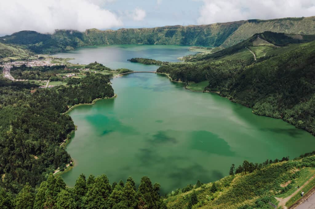
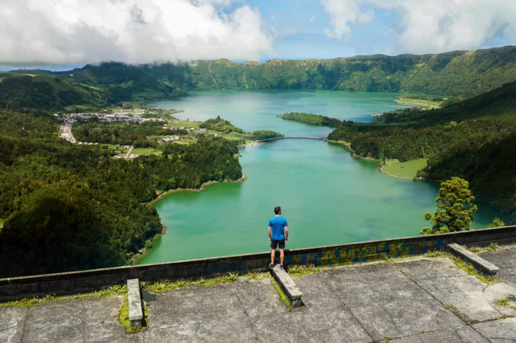
From Visto do Rei, you can also see down into the Caldeira das Sete Cidades, the volcanic crater that houses the Lagoa das Sete Cidades.
The photography opportunities are endless, and they change with the sun and the weather. We went twice: once in dense fog, and again two days later when it was mostly-sunny. The weather created two very different experiences!
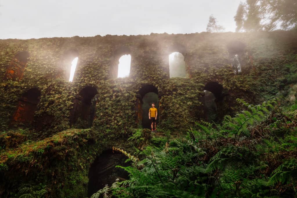
Hotel Monte Palace: Abandoned in the Azores
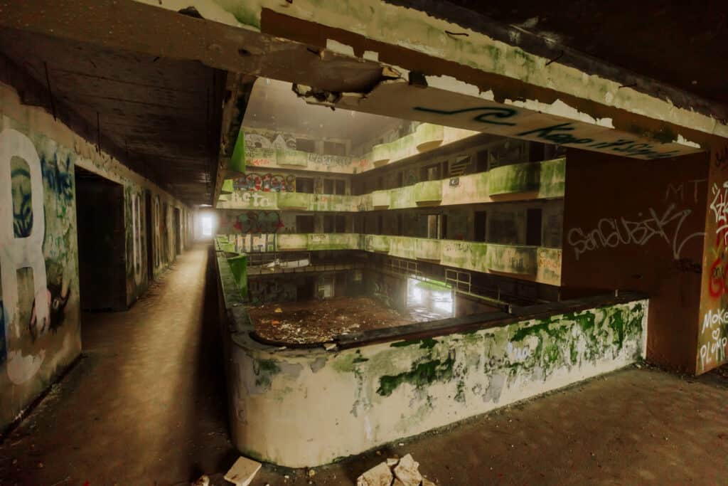
At the same Visto do Rei viewpoint, you can explore the abandoned hotel, which was once the most luxurious resort in the Azores.
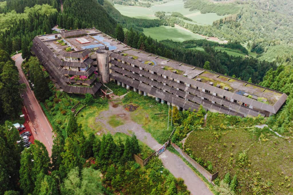
It wasn’t profitable, closed quickly, and was abandoned years ago.
Today, the windows are all broken out, and it’s a spooky shell of a once-glamorous resort. It’s full of soggy carpeting, graffiti, and peeling wallpaper and paint.
The views from the rooftop, which is accessible from a narrow staircase opposite the main entrance, are some of the best on the island.
Trail Details:
🔘 Distance from PDL: 15 miles
🔘 Trail Distance: Your choice!
🔘 Difficulty: Easy to moderate
🔘 Payoff: Views!
🔘 Public Hours: 24/7
🔘 Parking: Lot + roadside (Visto do Rei)
🔘 Services/Amenities: Food truck (sometimes)
🔘 Cost: Free
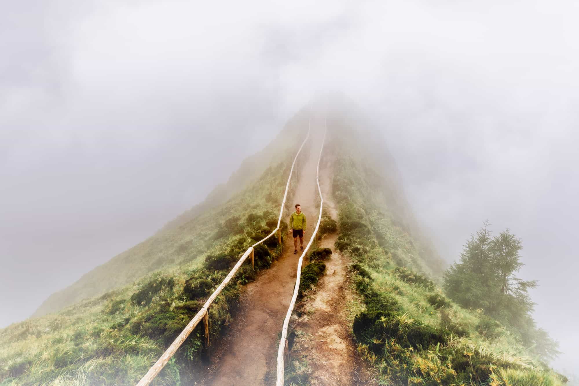
Miradouro da Grota do Inferno
The hike to the Grota do Inferno viewpoint (miradouro) will deliver one of the most memorable views of Sao Miguel.
There’s a fairly large dirt parking lot, which fits around 25 cars, near Lagoa do Canario (a lake near the road). It fills up quickly on clear days. When it’s full, people park on the side of the two-lane road.

You can expect a 1.6 mile round-trip hike to Groto do Inferno, which is almost entirely flat.
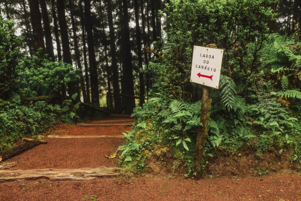
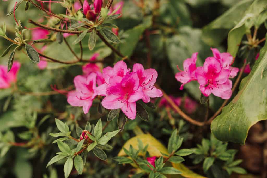
The trail here is more of a well-groomed dirt road, lined with lush trees and flowers.
The azaleas grow like weeds, and the hydrangeas bloom starting in May!
You’ll follow the dirt road (closed to traffic) for half-a-mile, passing the lake, Lagoa do Canario, along the way. Toward the end, you’ll follow a dirt trail for the final one-third of a mile to the viewpoint.
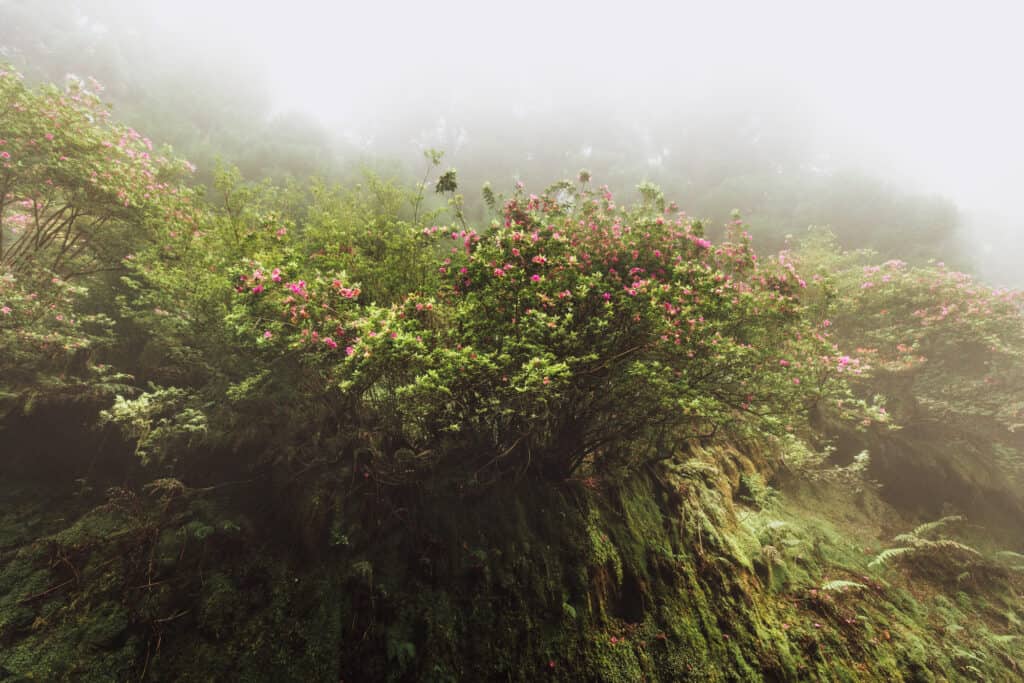
Weather (mainly fog) will play a big role in your trip to Grota do Inferno. We went on a foggy day, which created beautiful photos of the trail, but completely obscured our view of the volcanic lakes and landscape at the end of the trail.
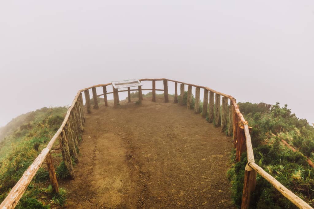
We truly had no idea what was beyond the fog and clouds at the end of the wooden railings!
Again, the photos are amazing and mysterious, but we had to go back a second time to get the full view.
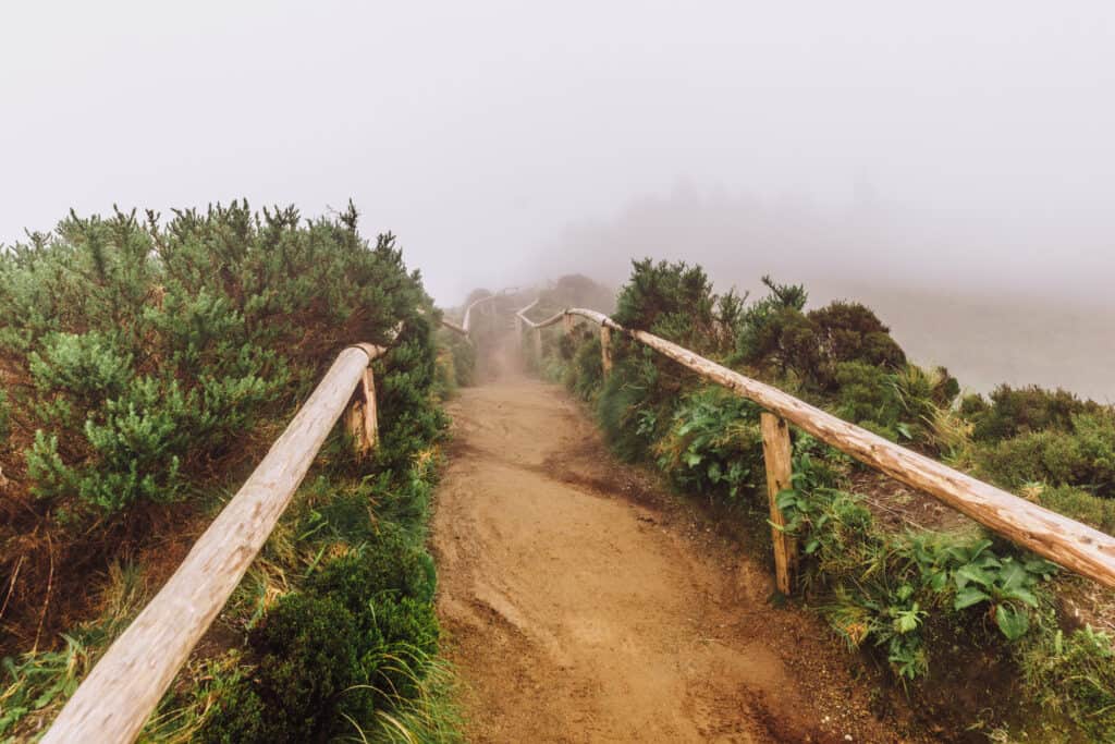
Keep in mind: even if it’s sunny by the coast or in Ponta Delgada, the mountains could be completely covered in fog! If it’s foggy, bring a poncho or raincoat, because you’ll get soaked by the end of your hike.
While this Azores hike was more of a stroll down a dirt road, I loved the lush surroundings. The rock walls are covered in thick moss and different grasses, while flowering shrubs form a canopy over part of the road.
Trail Details:
🔘 Distance from PDL: 12 miles
🔘 Trail Distance: 1.6 miles (out & back)
🔘 Difficulty: Easy
🔘 Payoff: Views!
🔘 Public Hours: 24/7
🔘 Parking: Lot + roadside (Lagoa do Canario)
🔘 Services/Amenities: Outhouse
🔘 Cost: Free
Salto do Cabrito
On the drive to the Salto do Cabrito hike, you’ll literally see steam venting from the earth’s crust on the side of the road!
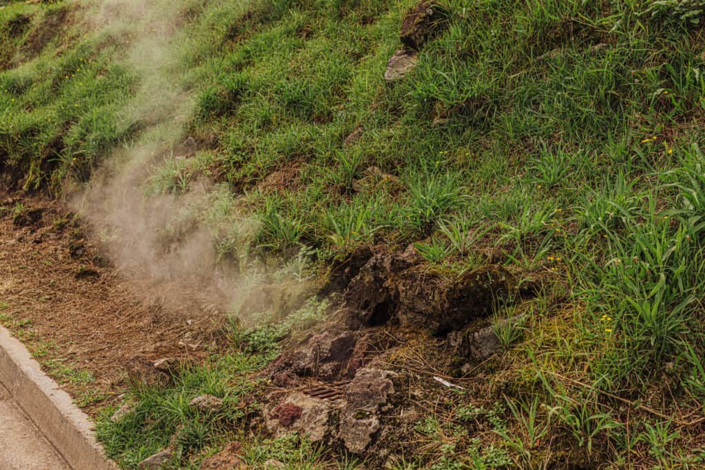
It’s another reminder that we have volcanic activity to thank for creating such a beautiful island! The waterfall hike is close to one of the famous hot springs.
The hike to Salto do Cabrito is about one mile (round-trip).
The parking lot has room for more than 20 cars.
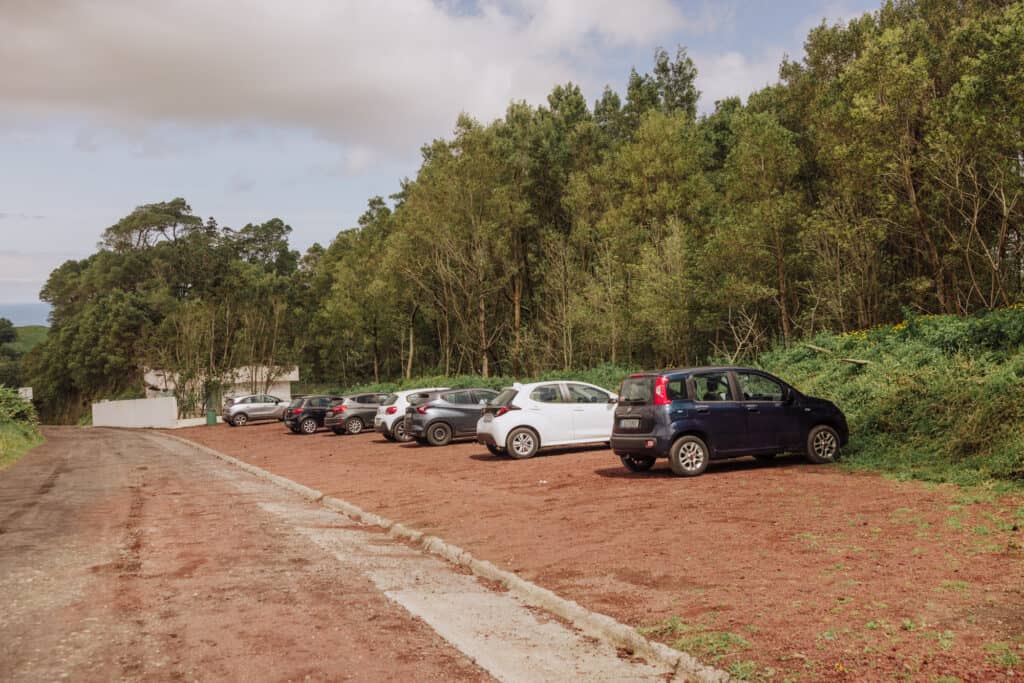
After parking, head back downhill, toward the old white building. The path to Salto do Cabrito begins as a narrow one-lane road, partially paved and full of potholes. Some people choose to drive down and park in the additional lot below. If you struggle with inclines, you should probably opt for that.
After passing a natural spring, keep walking beyond the second parking lot to the waterfalls. The first one you’ll pass is part of the hydroelectric power plant.
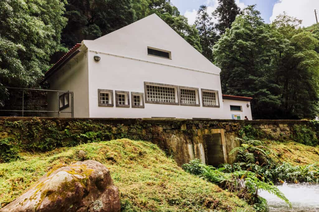
Continue walking, following signs for Salto do Cabrito. The waterfall will be just around the corner.
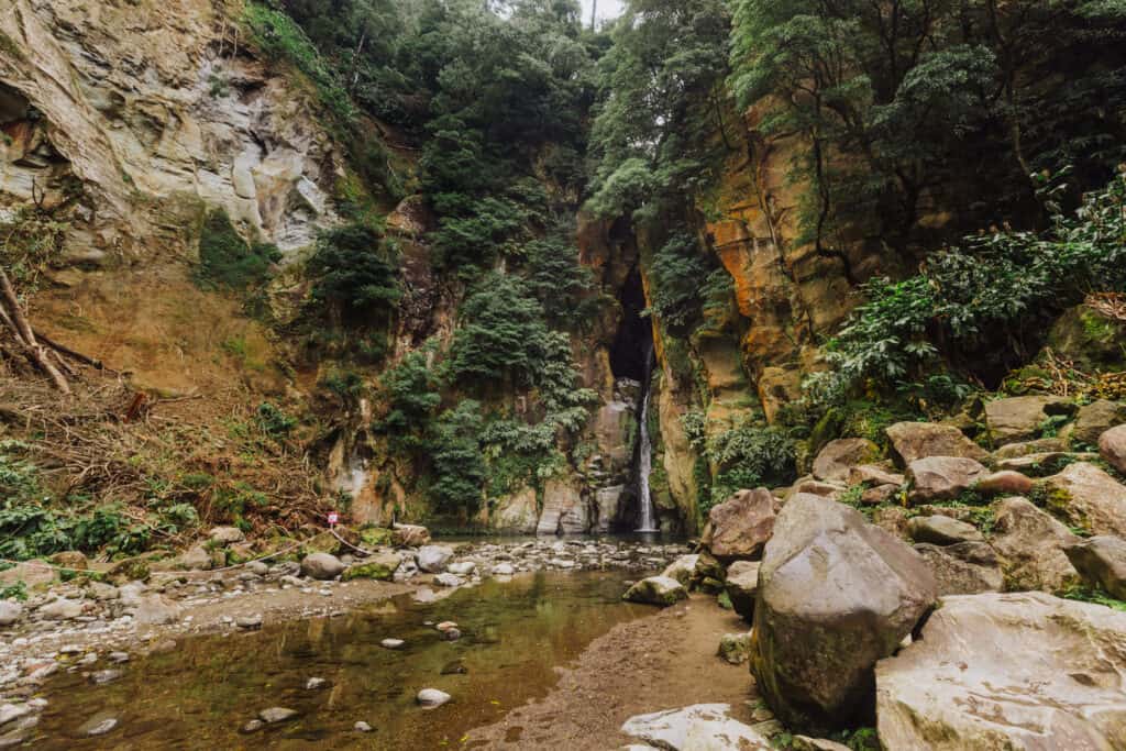
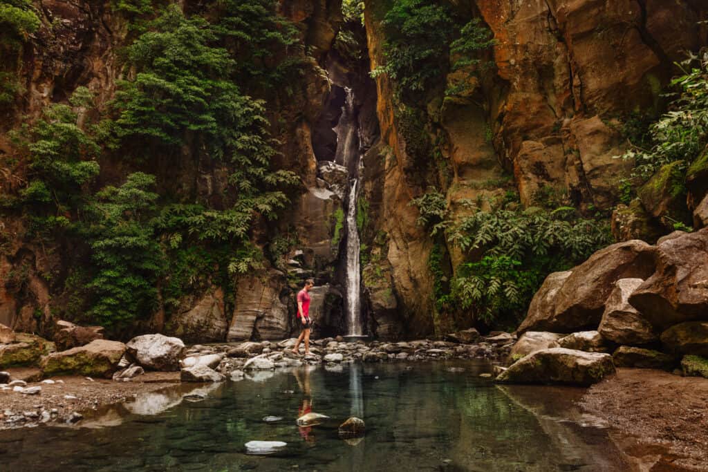
It’s a beautiful spot, and the water is deep enough to create a nice swimming hole. The water temperature is mild enough, but definitely not warmed by any of the geothermal activity below.
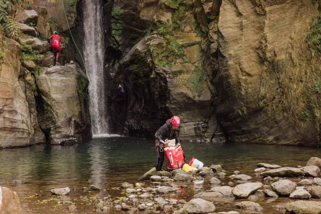
Salto do Cabrito is also a popular spot for canyoneering, which some people call canyoning.
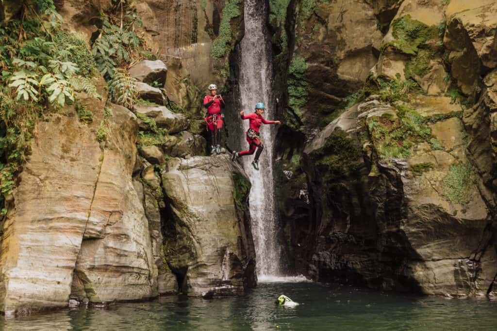
If you spend some time by the waterfalls, you might see a group drop down on ropes from the top of the cliff, and dive in off the final rock platform into the pool below.
Trail Details:
🔘 Distance from PDL: 15 miles
🔘 Trail Distance: 0.5 (each way)
🔘 Difficulty: Steep decline, then easy
🔘 Payoff: Waterfall + swimming hole
🔘 Public Hours: 24/7
🔘 Parking: Lot (Salto do Cabrito)
🔘 Services/Amenities: None
🔘 Cost: Free
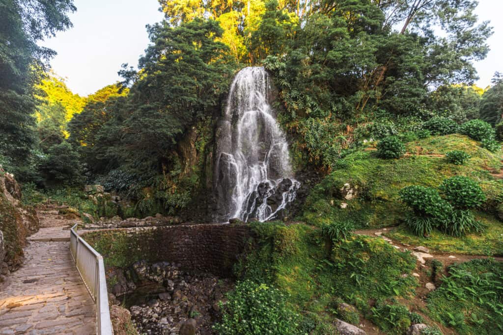
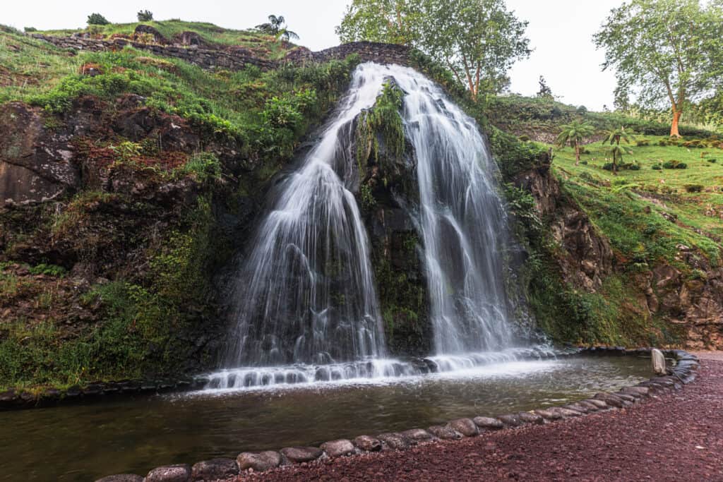
Ribeira dos Caldeiroes
Ribeira dos Caldeiroes, also known as Caldeiroes Park, is a popular natural park located in the northeastern part of Sao Miguel Island. Like all of the Sao Miguel trails and hiking spots, it’s known for its stunning waterfalls, lush vegetation, and picturesque landscapes.
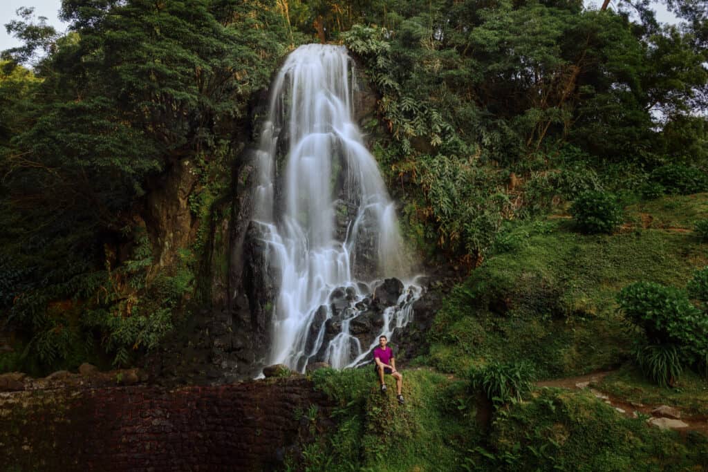
The park is home to a series of beautiful waterfalls formed by the Ribeira dos Caldeiroes stream as it cascades down the rugged terrain.
Ribeira dos Caldeiroes is another in the series of Azores hikes which offers well-maintained walking trails, rather than rugged terrain to hike through.
The main waterfall is right off the road, and very close to several parking lots.
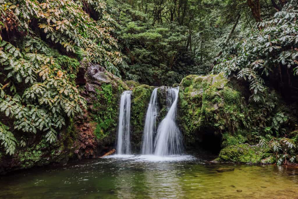
If you’re looking for more or a true hike, go beyond the waterfall on the trail to the side. It’ll lead you on more of an inclined dirt path to a much more secluded waterfall.
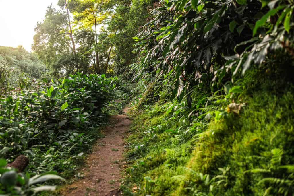
The trail is about a third of a mile, and it’ll lead to a waterfall in the forest, surrounded by lush green vegetation and tall trees.
A third waterfall can be found back down in the main part of the park. It’s more of a nice walk than a hike to get there. You’ll have a series of steps, but otherwise, this is a great option for seniors and kids.
Throughout the park, visitors can find traditional watermills that were once used to grind grain. These well-preserved mills are a reminder of the Azorean rural heritage and provide insight into the island’s historical agricultural practices.

Trail Details:
🔘 Distance from PDL: 30 miles
🔘 Trail Distance: 0.5 mile (each way)
🔘 Difficulty: Moderate (to second waterfall)
🔘 Payoff: Waterfalls
🔘 Public Hours: 24/7
🔘 Parking: Lot (Ribeira dos Caldeiroes)
🔘 Services/Amenities: Restaurant in the park
🔘 Cost: Free
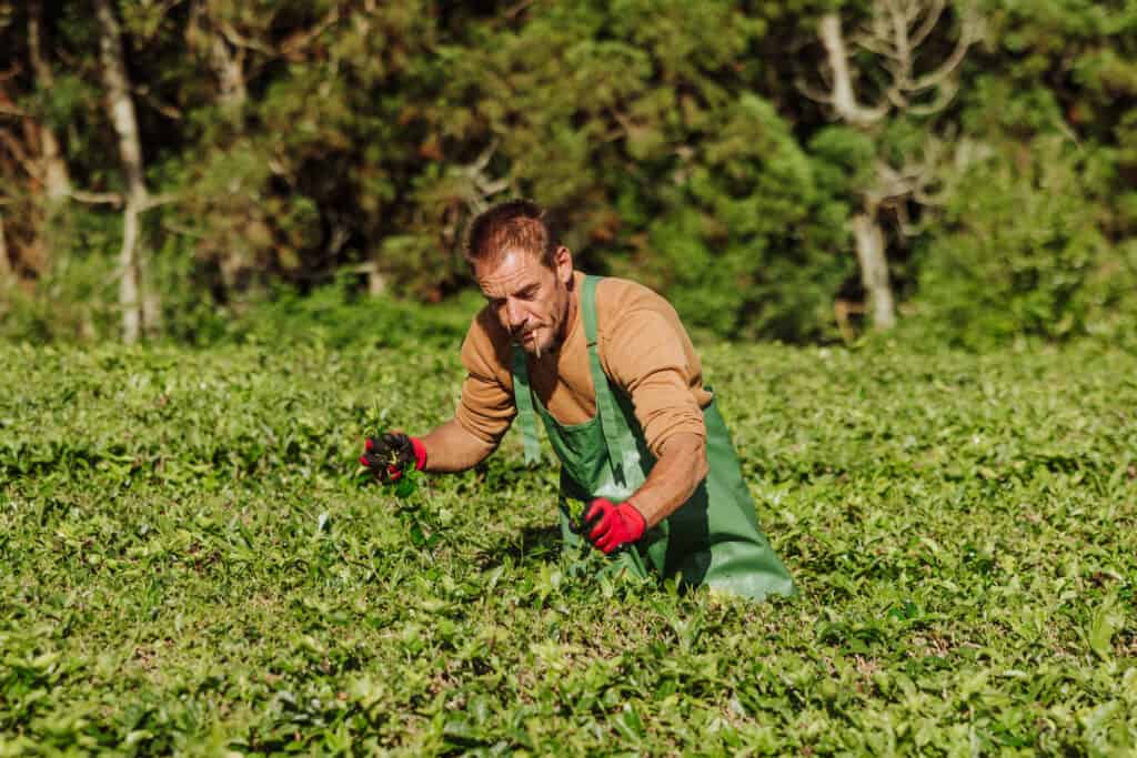
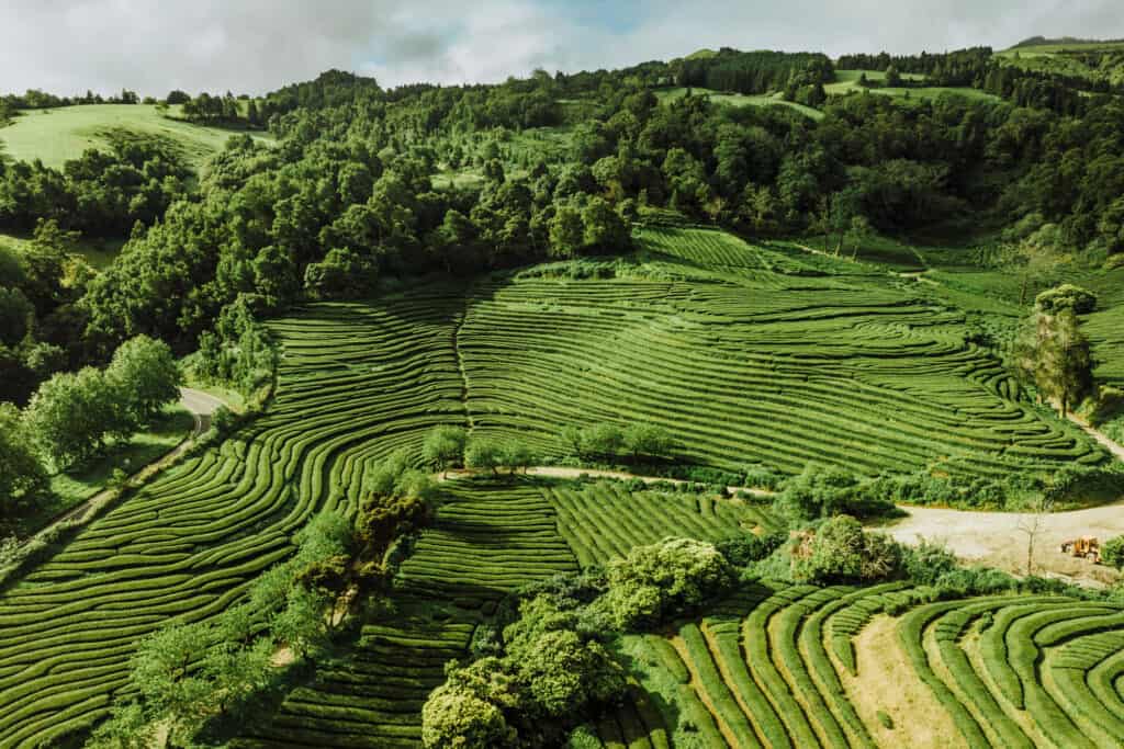
Gorreana Tea Fields
The scenery in the famous Azores tea fields is truly unique. The visuals lure a lot of hikers to check out the mazes on the hillsides of the Gorreana Tea Plantation.

The Gorreana Tea Plantation is on the northern coast of Sao Miguel, and is one of the oldest (if not the oldest) tea plantations in Europe.
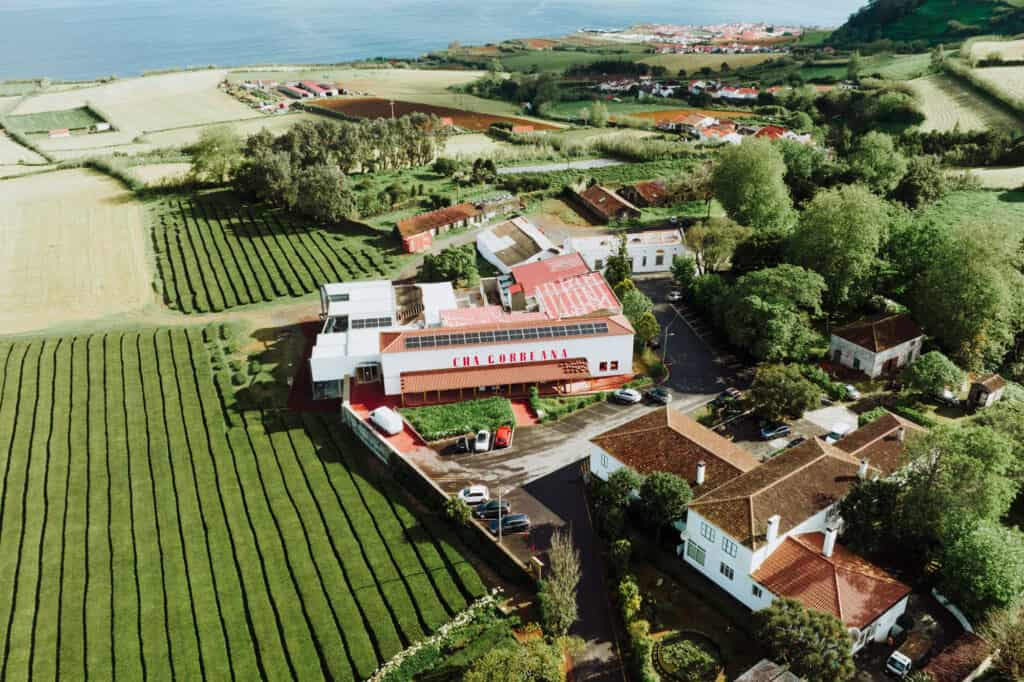
Even if you have no interest in tea, a visit to the Gorreana Tea Plantation is worth it, just for the hiking trails through the fields. The tea fields are open to the general public 24/7. There are no fees, and no gates!
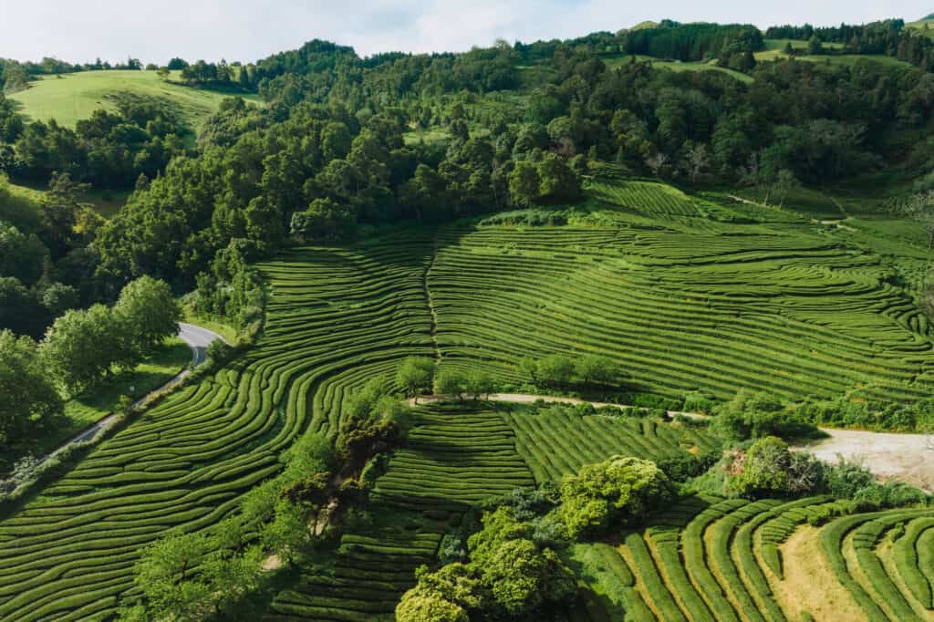
You can either wander aimlessly on your own through the dirt roads in the tea fields, or check out the official trailhead signs near the main building. The trails here will lead you through pastures and forests, and along roads and irrigation canals.
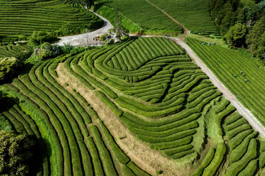
You’re likely to hike past the crews picking tea leaves in the fields.
This is another Azores hiking spot where the weather will create different kinds of experiences. We were there on a foggy, cloudy day, which created beautiful images.
Another morning we arrived at Gorreana before the pickers, just after sunrise, and the green mazes were stunning and vibrant.
Trail Details:
🔘 Distance from PDL: 22 miles
🔘 Trail Distance: Your choice!
🔘 Difficulty: Moderate (hilly)
🔘 Payoff: Views & unique maze
🔘 Public Hours: 24/7
🔘 Parking: Lot (tea factory)
🔘 Services/Amenities: Tea store
🔘 Cost: Free
Muro das Nove Janelas
I can’t call this a hike, per se, but Muro das Nove Janelas (translates to: The Wall of Nine Windows) is definitely a spot to check out as you drive around the viewpoints and hiking trails on the western side of Sao Miguel.
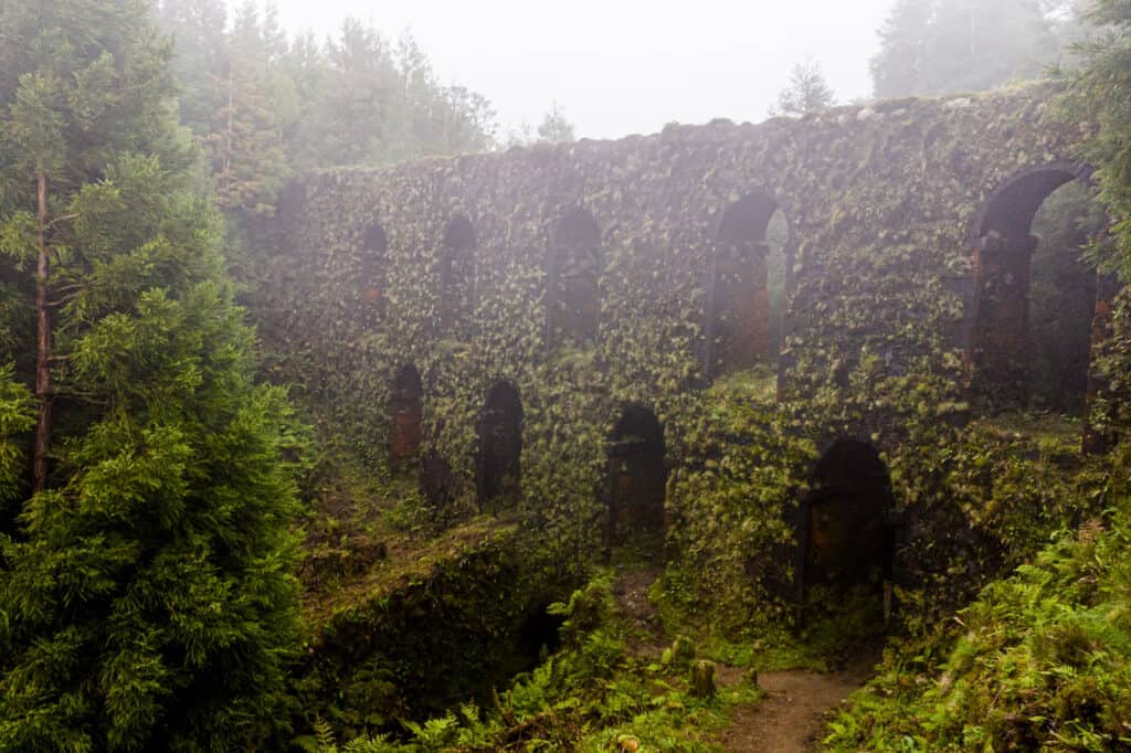
From the parking lot called Mata do Canario (on Google Maps), it’s an easy walk first to an aqueduct nearby. It’s 500 years old! The ancient waterline runs through a pasture, right off the road, so expect to see some animals grazing and farmers on their tractors.
I love the grasses and flowers growing right out of the rocks, along with the thick moss on the aqueduct.
You can either keep walking down to Mura das Nove Janeles, or drive right up to it. There’s a small roadside lot which might have some spaces.
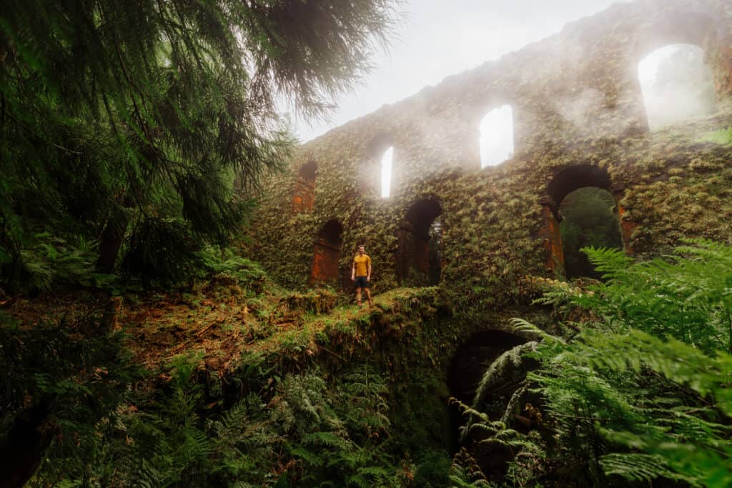
The structure dates back to the 1500s! The king at the time ordered the construction of a system to transport water from the hills down into Ponta Delgada. The aqueducts were built to carry the water over obstacles, like valleys or streams.
Muro das Nove Janelas was the largest section of the aqueduct, and it brought water from the lakes to the village. The arches were added to allow the strong winds to pass through the structure, and not compromise it.
The original aqueduct was rebuilt in 1830 to continue supplying Ponta Delgada with fresh water.
The aqueducts provide beautiful photography opportunities, whether it’s sunny or foggy. I love the look the fog gave our photos!
Trail Details:
🔘 Distance from PDL: 10 miles
🔘 Trail Distance: None
🔘 Difficulty: Easy
🔘 Payoff: Aqueduct system
🔘 Public Hours: 24/7
🔘 Parking: Lot (Mata do Canario)
🔘 Services/Amenities: None
🔘 Cost: Free
Salto do Prego
The hike to the Cascata do Salto do Prego (Salto do Prego Waterfall) is one of the “trails less traveled” on Sao Miguel. This is an Azores hiking trail where you might not see anyone else the whole time!

Salto do Prego is in the eastern part of the island, near the village of Faial da Terra. There’s a small trailhead parking lot.
The hike itself is less than two-miles each way, and is considered “moderately difficult.” Expect some uneven terrain and mud if it’s rained recently.
The scenery is lush and green, and the trail will take you over bridges to the Salto do Prego waterfall (which translates to “the waterfall of the spring”). It’s an appropriate name, since the waterfall is fed by a natural spring!
It’s chilly, but visitors can take a dip in the natural pool at the base of the waterfall, and have a picnic on the surrounding rocks.
Trail Details:
🔘 Distance from PDL: 45 miles
🔘 Trail Distance: 1.6 miles (each way)
🔘 Difficulty: Moderate
🔘 Payoff: Waterfall
🔘 Public Hours: 24/7
🔘 Parking: Lot
🔘 Services/Amenities: None
🔘 Cost: Free
Azores Hikes: The Beaches
The beaches on Sao Miguel are largely rocky and volcanic. You’ll find different trails and beach-walking opportunities around the island.
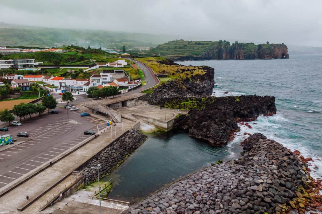
- Mosteiros: On the northwestern coast of Sao Miguel, you’ll find one of its most impressive beaches: Mosteiros, and the old fishing village just inland. The black rocks, set against the blue water are a beautiful sight. There are no real hiking trails here, but it’s a great spot to walk along the beach. Plus, with the rocks you’ll have to climb over, it’ll feel like a hike!
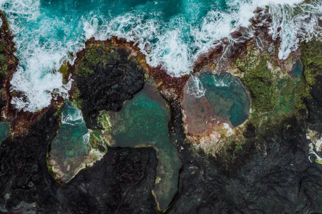
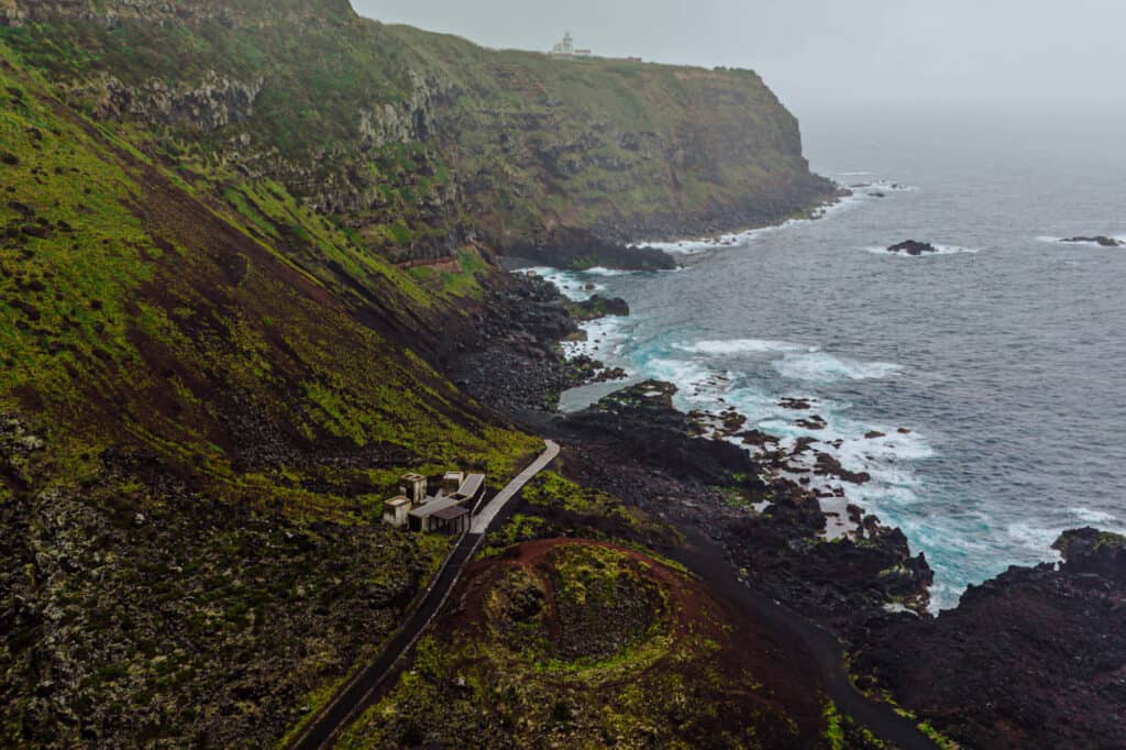
- Ponta da Ferraria: On the western coast of Sao Miguel, you’ll find a black beach famous for its hot springs and natural pool. The cold ocean water mixes with the hot spring water in a rock pool that’s very popular with locals. On the hike down the beach to get there, you’ll pass other interesting rock formations, too.
- Pocos de Sao Vicente: On the northern coast, you’ll find walking trails on the cliffs next to Pocos de Sao Vicente. This was an old whaling port, which turned into a manmade “natural” swimming pool. You can follow trails west of the swimming area, which will lead to viewpoints up on the cliffs.
The Best Time to Hike in the Azores
For me, the best time of year to head out on the Azores hiking trails would be May through September. To avoid the biggest crowds, I’d narrow down my target dates for the most ideal Sao Miguel hiking conditions to May and September.
The weather changes quickly on the islands in the Azores, from sunny to misty to rainy. Plus, there are different microclimates on Sao Miguel, so the weather will be different at different elevations and on the different coasts at the same time.
Layers will be key for any of the Azores hikes you decide to tackle!
In general, the climate is mild on Sao Miguel, and it never snows. Still, there are some seasonal variations which will impact the hiking trails:
Spring (March to May):
- Daytime temperatures typically range from 15°C to 20°C (59°F to 68°F).
- Expect some rainfall, but the island’s vegetation will be lush and green.
Summer (June to August):
- Summer is the peak tourist season in the Azores, so you’ll have crowded hiking trailheads.
- Daytime temperatures range from 20°C to 25°C (68°F to 77°F).
Autumn (September to November):
- Autumn brings slightly cooler temperatures, but still great hiking weather.
- Daytime temperatures range from 15°C to 20°C (59°F to 68°F).
- Rainfall increases as the season progresses.
Winter (December to February):
- Winter on Sao Miguel is mild but can be wet and windy.
- Daytime temperatures range from 12°C to 16°C (54°F to 61°F).
- Rainfall is more frequent, but again: it never snows.
The Best Hike on Each Island in the Azores
These are all up for debate, of course, but if you have some time to island-hop in the Azores, here are the hiking trails that are most popular on each:
Azores Hiking: Pico Island
The most popular hiking spot on Pico Island is the ascent of Mount Pico, also known as “Montanha do Pico.”
Mount Pico (Montanha do Pico) is the highest mountain in Portugal, standing at 2,351 meters (7,713 feet) above sea level. It’s a stratovolcano, which dominates the island’s skyline. The trail offers stunning panoramic views of the surrounding islands and the Atlantic Ocean.
Lagoa do Capitão, or Captain’s Lake, is another popular hiking spot on Pico Island. It’s a crater lake in a volcanic caldera. The trail takes you through lush vegetation and offers excellent views of the lake and its surroundings. It’s a less strenuous hike compared to Mount Pico.
Azores Hiking: Terceira Island
Serra do Cume is one of the most famous and scenic viewpoints on Terceira Island in the Azores. The viewpoint is located in the northern part of the island, near the town of Altares. The Serra do Cume hike is relatively easy and offers panoramic views of the island’s rolling green hills, farmlands, and the Atlantic Ocean.
The hike itself is considered easy, and the trail is well-marked and mostly flat, making it suitable for hikers of all levels and families with children.
Azores Hiking: Faial Island
The Caldeira is a massive volcanic crater on Faial Island and a popular hiking destination. The trail takes you through lush vegetation, and from the rim, you can witness the impressive size and depth of the caldera.
The trailhead for the Caldeira hike is easily accessible from various parts of Faial Island, including the main town of Horta. The total distance of the hike is around 3-4 miles.
Azores Hiking: Sao Jorge Island
The Faja de Sao Joao trail on Sao Jorge Island is a scenic hike that leads to the charming coastal settlement of Faja de Sao Joao. Sao Jorge Island is known for its rugged cliffs, deep valleys, and picturesque fajas (coastal flat areas formed by lava flows). The trailhead for the Faja de Sao Joao hike is located in the parish of Norte Grande, which is on the north coast of Sao Jorge Island. The total distance of the hike is less than 4-miles.
Azores Hiking: Flores Island
The hike at Morro Alto on Flores Island delivers breathtaking views of the island’s rugged terrain and coastal beauty. The Morro Alto trail is accessible from several points on the island, including the village of Fazenda. The trail is considered moderate, and involves some elevation gain. The round-trip hike is around 5-6 miles, depending on the route you choose.
Azores Hiking: Corvo Island
Corvo is the smallest and most remote island in the Azores. The Caldeirao hike is one of the island’s highlights, offering a glimpse into its volcanic past and natural beauty. The trail to Caldeirao starts in the village of Vila do Corvo, the only settlement on the island. The total distance of the hike is around 4-miles.
FAQs About Hiking in the Azores
Let’s tackle a few of the frequently-asked-questions about hiking in the Azores.
Which Azores island has the best hiking?
Sao Miguel has the most famous hikes, largely because it’s the most popular with tourists and the easiest to get to. The views are stunning from the inland mountain peaks, and also from the coastal trails. But the same can be said for the hikes on the other islands, too!
How difficult is the hiking in the Azores?
Most of the Azores hikes rank low-to-moderate, in terms of difficulty. You can blaze your own trail in spots, but for the most part, the trails are well-marked and maintained. Plus, no matter your ability level, you can find hikes in the Azores that suit your desires. Many of the hikes have very little elevation gain.
How far are the Azores from Portugal?
From Lisbon, it’ll be a two-hour flight to Ponta Delgada Airport on Sao Miguel.
What’s the Ponta Delgada Airport like?
The Ponta Delgada Airport (PDL) was renovated and expanded recently, to handle the influx of international tourists the islands are attracting. It’s still relatively small, and easy to maneuver.
Should you rent a car in the Azores?
Yes, renting a car in the Azores will help you get to more hiking destinations, hot springs, and beaches. Rental prices are very reasonable, and driving on Sao Miguel comes with very little traffic hassle.
What’s the best time of year to visit or hike in the Azores?
The crowds are biggest in the warm, sunny summer months of June and July. They start to drop slightly in August. If my schedule was completely open, I’d go hiking in the Azores in mid-to-late May (after the flowers start blooming) or in September.
Wrap: Final Thoughts on Hiking in the Azores
You’ll love hiking in the Azores for a variety of reasons. The scenery is top among them! It’s diverse, so after hiking along a beach full of black rocks, you can head to lush green hills or one of the volcanic lake trails.
The trails really aren’t overly challenging. You’ll find plenty of options for seniors and kids.
While the Azores are becoming increasingly popular as a tourist destination, many hiking trails remain tranquil, providing you with peace and solitude as you enjoy the stunning landscapes around you.
CHECK OUT OUR OTHER GUIDES TO THE AZORES: